Sunday, October 21, 2007

[07] Industrial and Commercial Organization

Lumber & Forestry
OR's major industries are in lumber, wood, timber, forest-product manufacturing. Around one-half the land area of the state is forested, with 40% production in commercial timber. Commercial forests are controlled by 60% public agencies and 40% private owners. The rest of the forest is under preservation, and recreational use.

Lumbering began in the Oregon Country in 1827 at Fort Vancouver. The first sawmill in the Willamette Valley was established by Ewing Young on Chehalem Creek in 1837. Young's mill supplied lumber for incoming settlers. In 1844 Henry Hunt established a mill above Astoria to make lumber for export to California. Later, the gold rush in California created a lucrative market for Oregon mills. By 1849 there were 37 sawmills in operation in the lower Willamette and Columbia region. The huge forest products industry continues to be a major part of Oregon's economy even after its downturn in the 1980s.

Since 1938, Oregon has ranked first in softwood lumber. By the late 20th century only 40% of the forest income was from lumber. Plywood accounts for 1/3rd of the value of forest products. Pulp, paper plants, hardboard, and particleboard plants contribute the remainder.

Fishing & Canning
Due to its situation near the ocean, it also has a large salmon fishing industry. Chinook, pink salmon and shellfish are valuable fishery products. Canning is also prominent in OR.

Commercial salmon fisheries developed in the 1860s, supporting early salmon-canning enterprises in Astoria, Tillamook Bay, Yaquina Bay, and Gold Beach. By the turn of the twentieth century commercial fishing was an important part of the economy of every major coastal town. Sportfishing later joined commercial fishing as an important part of the coastal economy and today it is a mainstay of the economies of Depoe Bay, Newport, Waldport, Florence, Winchester Bay, Gold Beach, and Brookings.

The Northwest salmon-canning industry got its start in 1866, when Hapgood, Hume & Co. built a cannery on the Columbia River at Eagle Cliff, on the Washington side.

By 1881 salmon canning was a major industry in the Pacific Northwest, and Astoria, by now the largest town on the Oregon coast, was its center. At the peak of the salmon canning industry there were thirty-nine canneries along the Columbia, and many others on Oregon's coastal rivers.
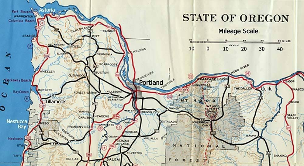

Locations of salmon canneries on the Columbia River and Oregon Coast
(click to enlarge)

Metals-related industries are conentrated in the Portland metropolitan area.

High-technology industries are found in Portland and the Willamette Valley.

Nike Retail Servies
The company's beginnings was at the University of Oregon in Eugene. Co-founder Phil Knight attended school there and co-founder Bill Bowerman coached track there.The business partnership began in 1964 as Blue Ribbon Sports (BRS). In 1972, BRS introduced a new brand of athletic footwear called Nike, named for the Greek winged goddess of victory. The first track star to wear Nike shoes was Steve Prefontaine, who was a native of Coos Bay, Oregon, and ran for the University.

The world headquarters for Nike are in Washington County,Oregon. This is near Beaverton, a suburb of Portland. There are 16 buildings at world headquarters. istribution centers are also operated in Wilsonville, Oregon. Apparel and equipment products are shipped from distribution centers in Tigard, Oregon. Approximately 7,000 work in Oregon at world headquarters, off-campus buildings, the Wilsonville distribution center and various retail venues combined.

The first Niketown opened in Portland, Oregon, in 1990. They employ over 4,000 Nike retail associates in the US and stores have been in operation worldwide since 1984. As of May 31, 2004, Nike had 137 factories in the Americas (including the US).

Stock Symbol: NKE
- became public in Dec 1980
- traded on the New York Stock Exchange.

Subsidiaries:
-Nike IHM, Inc. - Oregon based; makes AIR-SOLE cushioning components used in Nike footwear products and sells a low quantities of various plastic products to other manufacturers.
-Cole Haan Holdings, Inc.
-Bauer Hockey
-Hurley International LLC
-Converse, Inc.
-Exeter Brands Group LLC

Other Businesses
According to Oregon Business Magazine, they rated the top 100 businesses to work for in March 2007. In the top 5, most companies are communication-related industries. This list shows the top 5 (out of 100) surveyed large companies (those that have over 250 employees). The methodology used to determine the list are factors such as benefits and compensation, work environment, decision-making and trust, performance management, and career development and learning opportunites.


Company's location (city) and website.

US Cellular
Medford - http://www.uscellular.com/

Microsoft Corporation
Tigard - http://www.microsoft.com/

Qualcomm
Portland - http://www.qualcomm.com/

Carr Auto Group
Beaverton - http://www.carrauto.com/

Edge Wireless LLC
Bend - http://www.edgewireless.com/

Sources
Nike
OregonBusiness.com
Oregon History Project
Encyclopedia Britannica
Oregon Secretary of State Archives Division

[08] Connect Me Now!

Freeways
The major interstate in OR is the I-5. This runs north and south in California and into Washington state.

The state's interstate freeway system performs a vital function in the movement of people and cargo, with I-5 serving as the backbone for West Coast travel and the I-5/I-405 loop staking claim as the single most important transportation system in the State. The loop functions as the heart of the region's transportation system, connecting major community centers and providing access to National and regional transportation routes. The loop also provides access to the downtown Portland area on both sides of the Willamette River, which is important because downtown Portland serves as the cultural and civic center for the region and is home to about 20 percent of area employers.

Some cities located along or near the I-5 include: Portland, Lake Oswego, Tigard, Salem, Albany, Corvallis, Eugene, Sutherlin, Rosenburg, Grants Pass, Medford, and Ashland.

The I-5 is the preferred transportation corridor for quick north-south travel through Oregon. It is intersected by I-84, which travels east-west along northern Oregon . The length of the I-5 in Oregon is around 312 miles in length, with an estimated driving time of 4 hrs. & 41 minutes.

PDX - Portland International Airport


Terminal Map

Oregon's largest airport is located in Multnomah County. PDX is approximately 9 miles northeast of Portland. PDX services 15 major airlines, with Alaska/Horizon Air offering the most flights. It accounts for 90% passenger travel and over 90% air cargo.

Location: 7000 NE Airport Way, Portland, OR 97218

The Port of Portland
The Port of Portland was created in 1891. It was created to dredge a shipping channel from Portland to the Pacific Ocean. It owns marine terminals, four airports (Portland International, Hillsboro, Mulino and Troutdale) and seven business parks. By operating the dredge Oregon, it maintains the 40-foot-deep navigation channel on the lower Columbia and Willamette rivers.

Funding is divided among general port operations and aviation. General port operations include marine and industrial development, navigation, engineering, and the administrative divisions. Aviation is comprised of Portland International Airport (PDX) and three general aviation reliever airports located at Hillsboro, Troutdale and Mulino.

Rail
Railroads in OR were built around the 1870s. It allowed the agricultural economy a way to transport products without direct water access.

Portland, OR's Union Station

One way to travel by rail is through Amtrak Cascades. They are European-style trains with service in the Pacific Northwest. Daily service is available from Eugene, Oregon to Vancouver, British Columbia, with three daily round trips between Seattle's King Street Station and Portland's Union Station.

TriMet
Public transportation by bus, streetcar and lightrail is available through TriMet, which encompasses the Portland metro area and includings most of Clackamas, Multnomah and Washington counties. The most popular bus lines run every 15 minutes or better daily. There is no charge to ride in TriMet's fare-free zone, which includes most of Portland City Center and the Lloyd District. All TriMet service is accessible to people with disabilities.


Live Conditions
To check current road conditions in any location in Oregon, visit Trip Check.

Sources
Amtrak Cascades
TriMet
I-5 ORregon
Port of Portland

[05] Let's Talk Politics


OR State Capitol, Salem

State Governor
Theodore R. Kulongoski (D)
Elected in 2002 & reelected 2006
Term expires: January 2011

Senators (Congress)
Gordon Smith (R)
Ron Wyden (D)

House of Representatives (Congress):
Earl Blumenauer (D)
Peter DeFazio (D)
Darlene Hooley (D)
Greg Walden (R)
David Wu (D)

Electoral votes: 7

State Legislature
House: 60 seats
Senate: 30 seats


OR Capitol's House Chamber

Oregon has three branches of government: executive, legislative and judicial.

The Executive branch is composed of six statewide elected officials that administer and manage state agencies. The officials are the Governor, Secretary of State, Treasurer, Attorney General, Commissioner of Labor and Industries, and Superintendent of Public Instruction. The Governor is responsible for submitting a budget to the Legislature covering all state agencies every two years.

The Legislature's main functions are to finance state government, enact laws and provide an area for discussion of public issues. It reviews and revises the proposed budget and passes tax laws to provide revenue. The laws enacted by the Legislature establish state policies that, along with the adopted budget, direct all state agency activity.

The Judicial branch's function is to interpret the actions of the Legislature and state agencies as they relate to the Oregon Constitution. They also deliberate on civil, criminal and governance issues.

Voting Time...
Total Voter Registration, Nov. 2004: 2,141,249
Democratic
829,197 (38.72%)
Republican 761,717 (35.57%)
Non Affiliated 477,682 (22.31%)
Others 72,653 (3.39%)

Oregon has lead a vote-by-mail process. It experimented vote-by-mail in 1981 and became permanent in 1987. It was the first state to hold a Federal primary totally by mail in 1995. In 2000, Oregon was the first state to conduct a presidential election by mail with 80% of the registered voters participating.

36 counties
5 largest counties: Multnomah, Washington, Clackamas, Lane, Marion.

240 incorp. cities.
5 largest cities: Portland, Eugene, Salem, Gresham, Beaverton.


Counties of OR


Oregon's main political parties are the Democratic and Republican parties. Its minor state parties include the Constitution, Libertarian, and Pacific Green parties.

There are slightly more Democrats registered in OR as of 2000. In the Presidential election of 2004, OR's electoral vote went to Democrat candidate John Kerry.

Below is a breakdown of voter registration (by major political party lines) from 1910 to 2000.


Below is a breakdown of Democat and Republican registered voters by county.


Sources
U.S. Census Bureau
Oregon Secretary of State
Oregon
Welcome to Oregon

[06] Agriculture and Related Industries

According to the OR Dept of Ag, there are 6 major growing regions in the state.


1 - Coastal Oregon
2 - The Willamette Valley
3 - Southern Oregon
4 - Hood River Valley
5 - The Columbia Basin
6 - Southeast Oregon

Coastal Oregon
The Pacific Ocean provides many sea items like oysters, clams, salmon, bass, and scallops. Dairy farms found along the coast are well known for the cheese they produce. Dairy production is the largest near Tillamook on the north coast. Specialty crops in this region are cranberries and lily bulbs, which flourish due to the mild climate. Cranberries are produced along the south coast near Bandon and Port Orford. Easter Lilies (right)are found in abundance along the southern tip of the coast.

The Willamette Valley
This area runs from Eugene to Portland. This is a diverse area includes over 170 different items including grains, hays, nuts, berries, wines, Christmas trees, dairy, poultry and beef. Many sheep farms reside here, too. The capitol of OR, Salem, is located in this Valley; In the past, many pioneers settled here because of the fertile land. Lumber and farming became the first commercial enterprises as the farmers established saw and grist mills on Mill Creek. The mills were also relied on by neighbors to grind wheat and saw trees off lots.

Southern Oregon
In the hilly and mountainous areas of s. OR, sheep and cattle graze the land. Fruit, potatoes and livestock are also found here. Hood River Valley High quality tree fruits such as apples and pears are grown here. In The Dalles area to the east, there is a vast production of cherries.

The Columbia Basin
About 60% of the wheat production in the state takes place here. Farms here range from 4,000 acres or larger. Crops here include potatoes, alfalfa, wheat, watermelon, carrots, onions, field corn, etc.

Southeast Oregon
The livestock industry dominates this region where there is a low annual rainfall. Major crops include onions, potatoes, and sugar beets.

OR ranks first in production of...
Hazlenuts (filberts) (100% of U.S. production). [pic on right]
Fescue (100% of U.S. production).
Ryegrass (100% of U.S. production).
Blackberries (94% of U.S. production).

**National ranking highlights - 2004**


Sources
Stuff About States.com
Salem: Agricultural Overview
Agriculture in Oregon
ODA

Wednesday, September 12, 2007

[03] Who Settled in OR pre-1950?

NativesChinook Indian
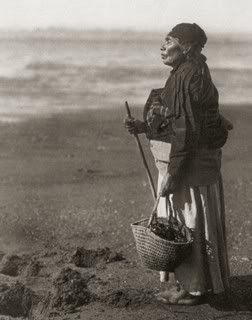
The first peoples to inhabit the area were nomadic hunter-gatherers that lived in small bands. Native tribes that settled in Oregon include the Chinook (pic to right), Tillamooks, and Nez Perce (to name some familiar ones). The ones on the coast took part in fishing activities where food was stored and harvested in summer and fall. The Chinookans carved canoes and made wooden spirit figures at grave sites. The Tututni and Chetco of the south coast bartered for raw materials. Western Oregon Indians had connections of trade and commerce reaching into northern California and to coastal Washington and British Columbia. They were involved in the flow of dentalium shells, elk hide armor, slaves, and surplus foods. Their lifeways echoed the strong traditions of art, ceremony, social class distinction, emphasis on wealth that ran for hundreds of miles along the North Pacific Coast.

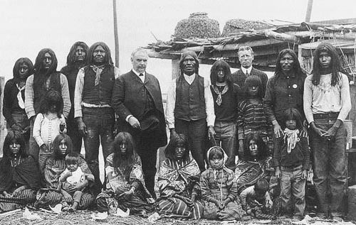
The people living between the Cascades and Rocky Mountains fished, gathered fruit, and hunted deer and elk. They had to rely on seasonal migration between rivers and upland areas. Their environment included summers that were hot and windy and winters that were cold and windy. Women picked berries in the nearby mountains and men ran down deer in the snow to secure meat and hides for clothing and moccasins. They dipped, clubbed, netted, and speared salmon and wind-dried them in curing sheds along the river.

The peoples of the Great Basin traveled in extended family groups or as bands for communal hunts. Great Basin residents had a mixed economy. They hunted, fished, trapped, dug, and picked food resources. They moved based on the seasons to search for subsistence.


Nez Perce Tribe

Nez Perce Indians


The first official recorded visit of the Oregon coast is in 1792 by Robert Gray. He was an American trading captain who came upon the Columbia River. His find was further investigated by William Broughton, a British Army lieutenant. He sailed up the Columbia River George. Eventually, a fur trade grew in the area between American and British entrepreneurs and native peoples. Such things they traded were beaver and sea-otter pelts, tools, weapons, and cloth.

By 1805, Lewis and Clark explored the area and found the site of present day Astoria. After their journey, many white pioneers (fur trappers and traders) came to claim the land for the US. Around the 1840s, many people began to pour into OR. Pioneers came from the east coast Border States and merchants came by ship lead to the population explosion that lead to the development of the OR Territory in 1848 and eventually statehood.


Photo Sharing and Video Hosting at Photobucket


The British Hudson's Bay Company, led by Dr. John McLoughlin, became the dominant force in the economy. This fur-trading company directed activities throughout the region and built the original capital of the Oregon Territory in Oregon City at the northern end of the Willamette Valley. In 1846, the British renounced claims in the area when signing the Oregon Treaty.

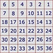
A major migration into the area happened in 1843 when pioneers traveled the Oregon Trail to settle in the Wullamette Valley. They depended on agriculture to make a living and wheat became a staple. In 1851, US surveyors divided the land into townships. This land measures 6 miles on each side, divded up into 36 sections, and each section had 640 acres.

In the 1870s, railroads were extended into the state. Waterway use became ineffective because of the availability of transport over the land. When automobiles were manufactured, the urban growth of the state began. Because of Oregon’s lush forestry, the logging industry came and the majority of logging activities take place in the state to provide for the rest of the country.


Sources
History of Oregon
Oregon Blue Book
General Oregon State History
Travel Guide: Fodor's Pacific Northwest

[04] Population Factoids Since 1950

Most people live in the Portland area and Willamette Valley area, especially around Salem and Eugene. The city of Portland had an estimated 539,438 residents in 2002 and the estimated population of Salem was 140,977; Eugene's was 140,395.

Population Trends
1980: 2,633,105
1990: 2,842,321
2000: 3,421,399
2004 estimate: 3,594,586

Percent change, 1990–2000: 20.4%

U.S. rank in 2004: 27th

Percent of residents born in state: 45.3% (2000)

Density: 35.6 people per square mile (2000)

Between 1970 and 1980, the state's net gain from migration was about 341,000; from 1980 to 1983, however, the state suffered a net loss of about 37,000, and from 1985 to 1990, the net migration gain was 123,500. Between 1990 and 1998, Oregon had net gains of 260,000 in domestic migration and 58,000 in international migration. In 1998, 5,909 foreign immigrants arrived in Oregon; of these, the greatest number, 1,879, came from Mexico. The state's overall population increased 15.5% between 1990 and 1998, making it one of the fastest growing states in the nation. In the period 1995–2000, 399,328 people moved into the state and 324,663 moved out, for a net gain of 74,665, many of whom came from California.

Racial and Ethnic Characteristics (2000)
White: 2,961,623
Black or African American: 55,662
American Indian and Alaska Native: 45,211
Asian: 101,350
Native Hawaiian and Pacific Islander: 7,976
Hispanic or Latino (may be of any race): 275,314
Other: 144,832

About 55,662 blacks were estimated to live in Oregon in 2000, up from 46,000 in 1990; most blacks reside in the Portland area. In 2000, Hispanics and Latinos numbered about 275,314, or 8% of the state total population, up from 113,000 in 1990. In the same year Asians numbered 101,350. There were 20,930 Chinese, 12,131 Japanese, 12,387 Koreans, 10,627 Filipinos, 18,890 Vietnamese (up from 8,130 in 1990), 9,575 Asian Indians (more than triple the 1990 population of 2,726), and 4,392 Laotians. Pacific Islanders numbered 7,976.

Age Characteristics (2000)
Population under 5 years old: 223,005
Population 5 to 19 years old: 720,999
Percent of population 65 years and over: 12.8%
Median age: 36.3 years (2000)

Vital Statistics
Total number of births (2003): 45,911
Total number of deaths (2003): 30,973 (infant deaths, 270)

Religion
Oregon has a high proportion of religiously-unaffiliated and self-identified "nonreligious" residents. 1.2% of Oregonians describe themselves as and 17% of Oregonians classify themselves as "nonreligious". The largest religion in OR is Christianity. Most people are part of the Catcholic Church, the Church of Jesus Christ of Latter-day Saints or the Evangelical Lutheran Church in America.


Sources
http://www.city-data.com/us-cities/The-West/Oregon.html

[02] Physical Landscape

Physiography
There are 6 major areas in OR: the Coast Range, the Willamette Lowland, the Cascade Mountains, the Klamath Mountains, the Columbia Plateau, and the Basin and Range Region.

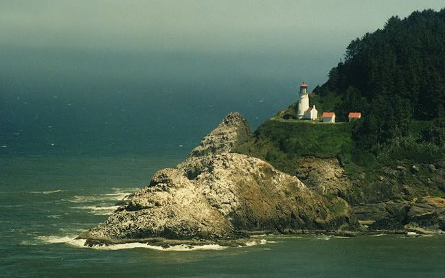
The Coast Range runs from north to south along the Pacific Ocean. Oregon has over 400 miles of public coastline. Its terrain varies from cliffs to forests to sharah-like dunes and sandy beaches. There are many lighthouses, coastal lakes, & state parks loacted on the coast. The mountains are covered with spruce, fir and hemlock. The average mountaintop in the Coast Range rises less than 2,000 feet above sea level. Along the coast, cliffs rise almost 1,000 feet high over the Pacific Ocean.


**About 1/10 of the nation's timber resides in the state of Oregon and it leads in lumber production in the states.

The Willamette Lowlands are a narrow strip of land to the east of the Coast Range along the Willamette River. The Willamette River flows north into the Columbia River. The soil is rich in the Willamette Lowlands and the climate is mild.

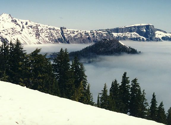
To the east of the Willamette Lowlands, the Cascade Mountains rise 11,239 feet above sea level (Mount Hood). Many of the nation's highest peaks can be found here. Other high peaks include Mt. Jefferson at 10,497 feet above sea level, Three Sisters, over 10,000 feet above sea level, and Mount McLoughlin, 9,495 feet high. Many lakes can be found in the Cascade Mountains, such as Crater Lake (Pic on right).


The Klamath Mountains (pic below) are located in the southwest and they are covered by dense forests.


Most of eastern Oregon is the Columbia Plateau. The Columbia Plateau (pic on right) was formed by lava flowing from cracks in the earth's crust. Many wheat farms are found here. Much of the Columbia Plateau is quite rugged, and mountains such as the Blue Mountains and the Wallowa Mountains rise in the northeast. On the Oregon/Idaho border the Snake River has cut Hells Canyon deep into the earth. The average depth of this gorge, located between the Wallowa Mountains and the Seven Devils Mountains in Idaho, is 5,500 feet.

The Basin and Range region is located in southeastern Oregon, marked by high basins and a few steep mountains. It is mainly characterized by semi-desert conditions.

Above info provided by NETSTATE.

Climate
States in the Paficic Northwest have a reputation for quickly changing weather patterns. Oregon's is known for having rainy conditions, especially during the winter. However, that is not always the case during the other parts of the year.

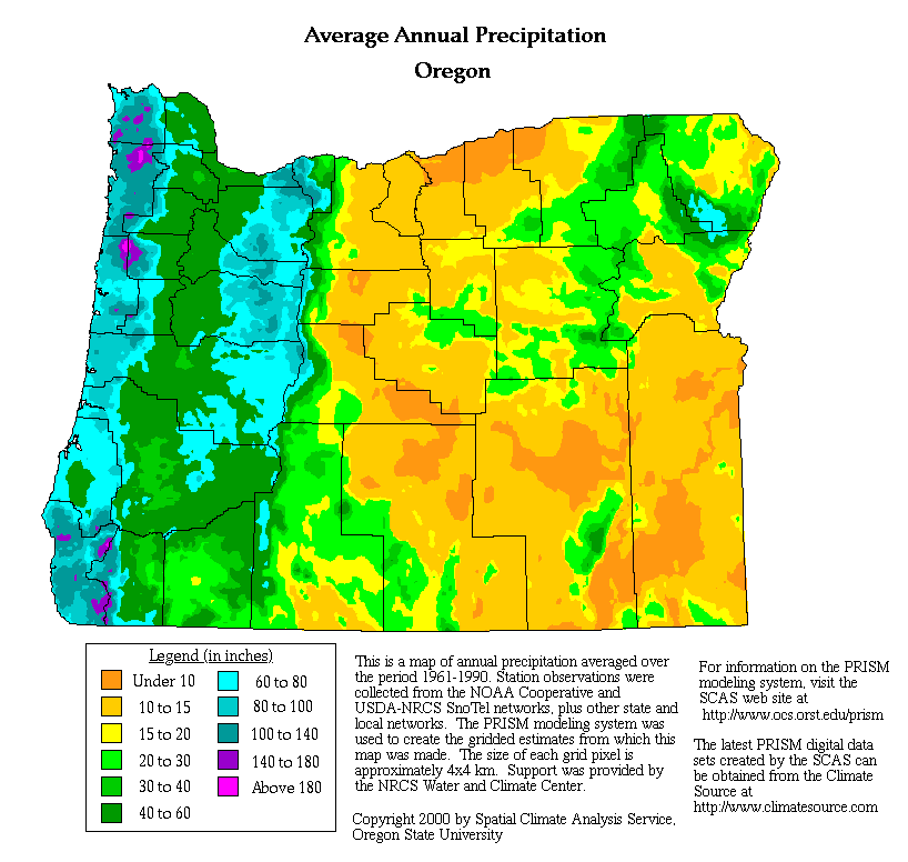
Oregon's average yearly precipitation, from 1961 to 1990, is detailed by Oregon State University. (click to enlarge)


Western Oregon experiences mild winters due to moist, mild ocean winds. Its summers are also mild, with the west and central area cooler than the rest of the state. Summers are usually mild and warm. Precipitation various throughout the state. Normally, the southeast is dry and the west gets rains.

Much of the state is considered a desert, and the area west of the Cascades gets the most rain. Beginning on the east end, Oregon begins as a high, sage-scented desert plateau that covers 2/3rds of the state. Moving west, Oregon's landscape rises to alpine peaks, meadows, and lakes; plunges to fertile farmland and forest; then ends up at the cold Pacific Ocean.

Mean temperatures average 38 degrees in January, near 67 degrees in July. Cooler summer temperatures are common in the east and southeast, and in the Cascade Mountains. It's a bit warmer than normal in the southwestern corner of the state. (World Atlas.com)


Average highs and lows for selected OR cities


http://www.ustravelweather.com/weather-oregon/


Precipitation amounts vary from 8 inches annually in the drier plateau regions east of the Cascades, to as much as 200 inches in the higher elevations of the Coast Range mountains. Snow amounts approach 350 to 550 inches annually in the Cascades. (World Atlas.com)


Check out current weather conditions in:

Click for Forecast
Click for Forecast

For a more detailed report on OR's climate, visit Oregon Climate Service.