There are 6 major areas in OR: the Coast Range, the Willamette Lowland, the Cascade Mountains, the Klamath Mountains, the Columbia Plateau, and the Basin and Range Region.
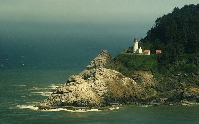 The Coast Range runs from north to south along the Pacific Ocean. Oregon has over 400 miles of public coastline. Its terrain varies from cliffs to forests to sharah-like dunes and sandy beaches. There are many lighthouses, coastal lakes, & state parks loacted on the coast. The mountains are covered with spruce, fir and hemlock. The average mountaintop in the Coast Range rises less than 2,000 feet above sea level. Along the coast, cliffs rise almost 1,000 feet high over the Pacific Ocean.
**About 1/10 of the nation's timber resides in the state of Oregon and it leads in lumber production in the states.
 The Willamette Lowlands are a narrow strip of land to the east of the Coast Range along the Willamette River. The Willamette River flows north into the Columbia River. The soil is rich in the Willamette Lowlands and the climate is mild.
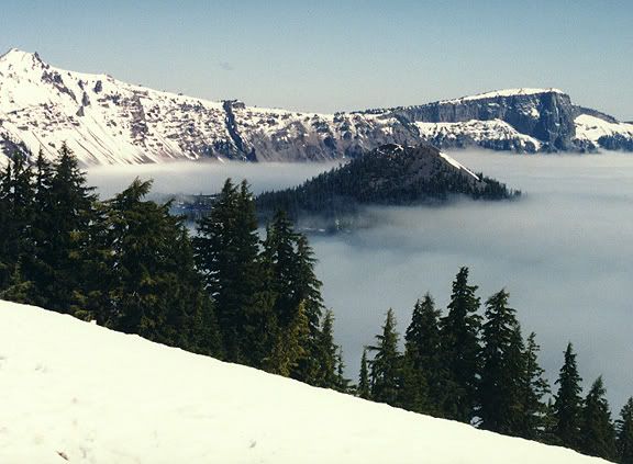
To the east of the Willamette Lowlands, the Cascade Mountains rise 11,239 feet above sea level (Mount Hood). Many of the nation's highest peaks can be found here. Other high peaks include Mt. Jefferson at 10,497 feet above sea level, Three Sisters, over 10,000 feet above sea level, and Mount McLoughlin, 9,495 feet high. Many lakes can be found in the Cascade Mountains, such as Crater Lake (Pic on right).
The Klamath Mountains (pic below) are located in the southwest and they are covered by dense forests.

 Most of eastern Oregon is the Columbia Plateau. The Columbia Plateau (pic on right) was formed by lava flowing from cracks in the earth's crust. Many wheat farms are found here. Much of the Columbia Plateau is quite rugged, and mountains such as the Blue Mountains and the Wallowa Mountains rise in the northeast. On the Oregon/Idaho border the Snake River has cut Hells Canyon deep into the earth. The average depth of this gorge, located between the Wallowa Mountains and the Seven Devils Mountains in Idaho, is 5,500 feet.
The Basin and Range region is located in southeastern Oregon, marked by high basins and a few steep mountains. It is mainly characterized by semi-desert conditions.
Above info provided by NETSTATE.
Climate
States in the Paficic Northwest have a reputation for quickly changing weather patterns. Oregon's is known for having rainy conditions, especially during the winter. However, that is not always the case during the other parts of the year.
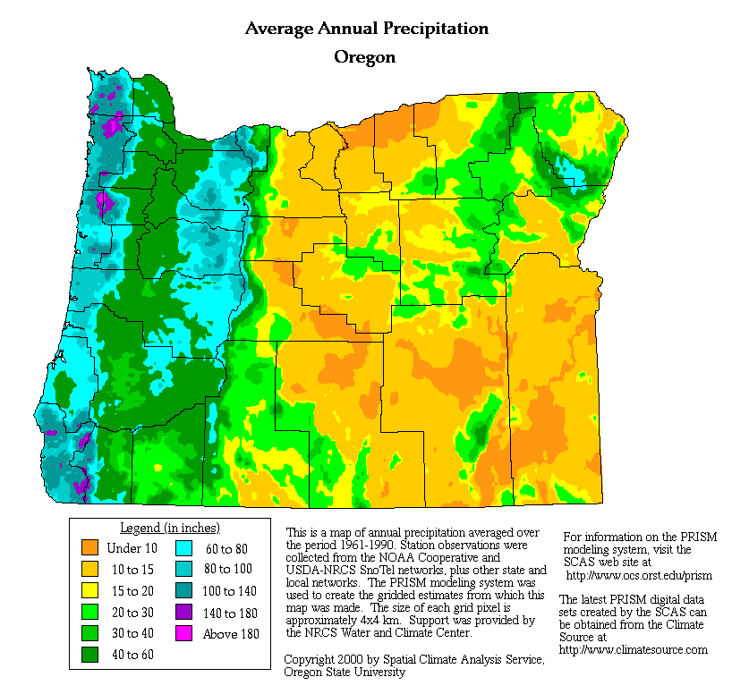
Oregon's average yearly precipitation, from 1961 to 1990, is detailed by Oregon State University. (click to enlarge)
Western Oregon experiences mild winters due to moist, mild ocean winds. Its summers are also mild, with the west and central area cooler than the rest of the state. Summers are usually mild and warm. Precipitation various throughout the state. Normally, the southeast is dry and the west gets rains.
Much of the state is considered a desert, and the area west of the Cascades gets the most rain. Beginning on the east end, Oregon begins as a high, sage-scented desert plateau that covers 2/3rds of the state. Moving west, Oregon's landscape rises to alpine peaks, meadows, and lakes; plunges to fertile farmland and forest; then ends up at the cold Pacific Ocean.
Mean temperatures average 38 degrees in January, near 67 degrees in July. Cooler summer temperatures are common in the east and southeast, and in the Cascade Mountains. It's a bit warmer than normal in the southwestern corner of the state. (World Atlas.com)

http://www.ustravelweather.com/weather-oregon/
Precipitation amounts vary from 8 inches annually in the drier plateau regions east of the Cascades, to as much as 200 inches in the higher elevations of the Coast Range mountains. Snow amounts approach 350 to 550 inches annually in the Cascades. (World Atlas.com)
Check out current weather conditions in:


For a more detailed report on OR's climate, visit Oregon Climate Service.
I like your pics. : o
ReplyDelete