
Outline of the state of OR
395 miles wide (east to west at widest point)
Capital
Salem
Largest City
Portland (City of Roses)
Statehood
February 14, 1859 (33rd state)
**notice something peculiar about the date? Valentine's Day!**
Timezone
Pacific Standard/Daylight Time
Flag
Oregon is the only state with a double-sided flag. Its colors are navy gold and blue, representative of Oregon's state colors. The 33 stars on the front of the flag represent the number of states at the time of statehood admission. Ships are representative of trade and the eagle is a symbol of the United States. The back has a beaver, which is Oregon's state animal.


State Name Origin:
The exact name origins of Oregon are unknown, but there are several beliefs on how it came to be.
It is believed to come from the French Canadian word "ouragan" meaning "storm" or hurricane" or possibly the Spanish word "orejon" meaning "big-ear" or the Spanish word "oregano" for the wild sage that grows in the eastern part of the state.
... According to SHG Resources ...
The first written record of the name "Oregon" comes to us from a 1765 proposal for a journey written by Major Robert Rogers, an English army officer. It reads, "The rout... is from the Great Lakes towards the Head of the Mississippi, and from thence to the River called by the Indians Ouragon. ..." His proposal rejected, Rogers reapplied in 1772, using the spelling "Ourigan."
The first printed use of the current spelling appeared in Captain Jonathan Carver's 1778 book, "Travels Through the Interior Parts of North America 1766, 1767 and 1768." He listed the four great rivers of the continent, including "the River of Oregon, or the River of the West, that falls into the Pacific Ocean at the Straits of Annian."
Historians say Oregon was most likely named after one of two rivers. The Columbia River, which forms a coastline along the northern border, was at one time called the Oregon or Ouragan, which is French for hurricane. Others believe the name was derived from a mapmaker's error in the 1700s. The Wisconsin River was named the Ouisconsink and was picked up by travelers referring to the country west of the Great Lakes as Ourigan.
Population
2006 estimate: 3,700,758 (US Census)
Size
Land area: approx. 95,997 sq miles
Location
Coordinates: 44.924N, 123.022W
Geographic Center: approx 25 miles to the southeast of Prineville, in Crook County
Highest Point: Mount Hood @ 11,239 ft.
Lowest Point: Sea Level on Pacific Coast
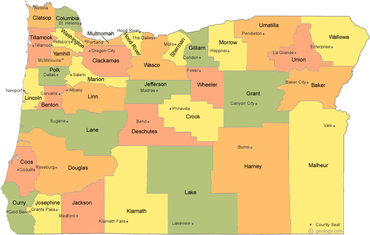
# of Counties: 36
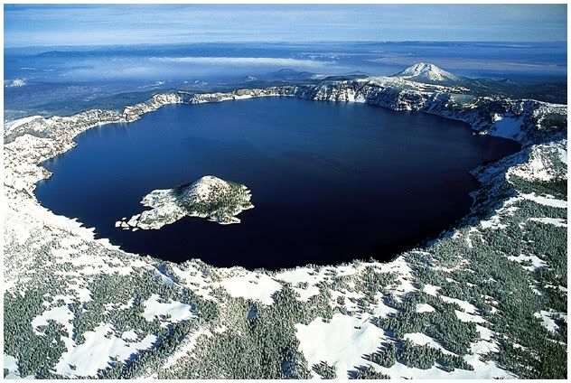
Deepest Lake in the US: Crater Lake (Klamath County). Depth of 1,932 feet.
State...
Motto: "She flies with her own wings."
Animal: Beaver
Fish: Chinook salmon
The State Quarter

Oregon was the 3rd quarter to be released in 2005. The coin shows off Crater Lake, and it includes Wizard Island and Watchman and Hillman Peaks on the lake’s rim and conifers.
Other Interesting Facts
1. Oregon has more ghost towns than any other state.
2. Oregon and New Jersey are the only states without self-serve gas stations.
3. Eugene was the first city to have one-way streets.
4. At 329 feet, the Coast Douglas-Fir in Oregon is considered the tallest tree in the state.
5. At 8,000 feet deep, Hells Canyon is the deepest river gorge in North America.
6. The hazelnut is Oregon's official state nut. Oregon is the only state that has an official state nut. The hazelnut is also known as the filbert.
7. The nation's most photographed lighthouse is the Heceta Head Lighthouse located in Lane County.
8. Tillamook is home to Oregon's largest cheese factory.
9. The Columbia River forms most of the northern border between Oregon and Washington. The Snake River forms over half of the eastern boundary with Idaho.
No comments:
Post a Comment